Read the City Like a Map: How Reykjavik's Harbor and Hills Do the Navigating for You
Here's a travel truth that most guidebooks won't tell you: the best navigation tool in Reykjavik isn't your phone. It's the city itself.
Reykjavik has something that a lot of capital cities don't — a geography so distinct, so readable, that once you understand its basic logic, you can pocket your device and just walk. The harbor pulls you north. The mountains anchor the east. The ground beneath your feet literally tilts in ways that tell you exactly where you are. It's a system that locals use instinctively, and visitors can learn surprisingly fast.
This guide breaks it all down so you can spend less time squinting at a screen and more time actually seeing the city.
Start With the Big Picture: Reykjavik's Natural Layout
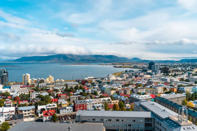
Before you leave your accommodation, take five minutes to understand the city's basic shape. Reykjavik sits on a peninsula, which means water is never far away — and that's your first major advantage. The Atlantic Ocean and Faxaflói Bay wrap around the city's northern and western edges, while the famous harbor area anchors the central-northern part of downtown.
To the north and northeast, across the bay on a clear day, you'll see the long white ridge of the Esja mountain range. That ridge is your fixed point. It doesn't move, it doesn't reroute, and it shows up from almost every elevated spot in the city center. Memorize its silhouette on day one. Seriously — it'll save you more than any app.
The general rule of thumb: if Esja is in front of you, you're heading roughly north toward the harbor. If it's behind you, you're heading south and inland toward the quieter residential neighborhoods. Simple as that.
The Harbor Is Your Anchor Point
Reykjavik's Old Harbor — the working waterfront packed with fishing boats, whale-watching tours, and the occasional dramatic fog bank — is the single most reliable landmark in the city. It's visible from a huge swath of downtown, and once you've stood at the water's edge even once, you'll have a visceral sense of where "north" lives.
When you're disoriented somewhere in the city center, ask yourself: can I see or smell the harbor? Water has a way of announcing itself. Walk toward it, get your bearings, and reset from there. Think of the harbor the way New Yorkers think of the direction of midtown — it's a fixed reference point that snaps everything back into place.
The Harborhouse area also gives you a visual corridor. The streets in central Reykjavik tend to run at angles that naturally funnel you toward or away from the water. If you're on Lækjargata or Hafnarstræti and you keep walking the way those streets slope, you'll hit the harbor almost every time.
Use the Slope: Reykjavik Literally Points You Downhill to the Water
This is the navigation hack that most visitors overlook entirely, and it's maybe the most useful one. Reykjavik's downtown is built on a gentle but noticeable hill. The city rises as you move south and inland, and drops as you head toward the harbor.
What that means in practice: if you're unsure which way is which, pay attention to the ground beneath your feet. Walking uphill generally means you're moving away from the harbor, into the higher residential streets and toward neighborhoods like Hlemmur and Laugardalur. Walking downhill — even slightly — tends to pull you back toward the waterfront and the historic core.
It's not a dramatic elevation change, but it's consistent enough to feel. Especially if you've been walking for a while, your legs will tell you which direction you've been trending.
Hallgrímskirkja: The Steeple That Watches Over Everything
You've seen the photos. Hallgrímskirkja, the enormous concrete church with the rocket-ship silhouette, dominates the Reykjavik skyline from pretty much everywhere in the city center. And that's exactly what makes it such a powerful navigation tool.
The church sits on one of the highest natural points in central Reykjavik, which means its tower is visible from a remarkable number of streets and intersections. When you're turned around somewhere in the 101 postal district, look up. If you can spot the steeple, you've got a landmark that tells you you're looking roughly south-southeast — and that the harbor is in the opposite direction.
Better yet, climb it. The observation deck at the top of Hallgrímskirkja gives you a 360-degree orientation session that no map can replicate. You'll see exactly how the city's grid relates to the water, where the mountains sit relative to downtown, and how the neighborhoods fan out from the historic core. Spend twenty minutes up there on your first full day in the city, and consider it your personal orientation briefing.
Vantage Points Worth Seeking Out
Hallgrímskirkja isn't the only elevated spot worth visiting with navigation in mind. A few others that give you genuinely useful orientation moments:
Öskjuhlíð Hill and Perlan — The dome of Perlan sits on a forested hill just south of downtown, and the views from its observation deck show you the full sweep of the peninsula. You'll see immediately how the harbor curves, where the mountains sit, and how compact the city center actually is.
The Sæbraut Coastal Road — Walking or cycling along this waterfront path gives you a horizontal read on the city rather than a vertical one. With the bay on one side and the city rising on the other, you get a clear sense of the relationship between the built environment and the natural geography.
Arnarhóll Hill — This small grassy knoll near the harbor and the government buildings is easy to overlook, but standing on it gives you a surprisingly clear view of how the city center is organized. The statue of Ingólfr Arnarson at the top is worth a look too.
Putting It All Together on the Street
Here's the practical version of everything above, distilled into a quick mental checklist for when you're standing on a random corner and have no idea which way to go:
- Look for Esja. The mountain range across the bay is north. If you can see it, you know your cardinal directions.
- Find the slope. Downhill equals harbor. Uphill equals inland.
- Spot Hallgrímskirkja. The steeple is south-southeast of the harbor. Use it to triangulate.
- Trust the water. If you're near the ocean, you're near the harbor, and the harbor is your reset point.
Reykjavik rewards walkers who pay attention. The city isn't that big — the entire downtown core is genuinely walkable in a way that American cities rarely are — and its geography is surprisingly legible once you know what to look for. You don't need a data plan or a roaming package to get around. You just need to look up once in a while.


